PLUS PACK BUNDLE
You get them all in one bundled subscription!
V-Soft Communications now provides the “Plus Pack”, a special subscription package of extra program capabilities for Probe 5 and FMCommander. A number of useful modules, currently offered as optional features in both Probe and FMCommander, are now bundled together and available on a subscription basis for one attractive low price.
Bundled Probe 5 Options:
1. Synchronous Booster
This sophisticated program module is used to determine interference areas in systems containing on-channel boosters and single frequency networks. The “Time Delay” module allows the user to examine the effect that different time delays in signal origination have on the predicted interference area. With the input of “acceptable” time delay in microseconds and acceptable signal differences in dB between the primary station and the booster, Probe’s mapping displays will define areas where the arriving signals will be far enough out of sync to cause appreciable signal distortion. Both graphical and tabular population reporting is available for the areas defined as having interference. Examples and more information are available on the V-soft web site at: Probe Booster Time Delay Module
2. Measured Signal Option
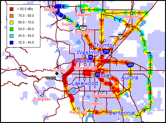
This Probe 5 option will import measured signal data from several brand name GPS automatic measuring devices. A “snail trail” map shows the color coded measured field strength points along the drive path of an FM or TV station. Circles are bounded by thin black line boundaries to make then stand out. Probe 5 handles measured data imports from Audemat, Z-Technology and other GPS/signal measuring devices. Once imported, you can ask Probe to display a Longley-Rice map with the measured data merged with the predicted data. Probe will give more weighting to the measured points at and around the locations of the measured data. For those locations where there is no measured data, Probe will use Longley-Rice or another user selected propagation algorithm. For more information on this module see: Probe Measured Signal Module
3. Pattern Workshop Editor
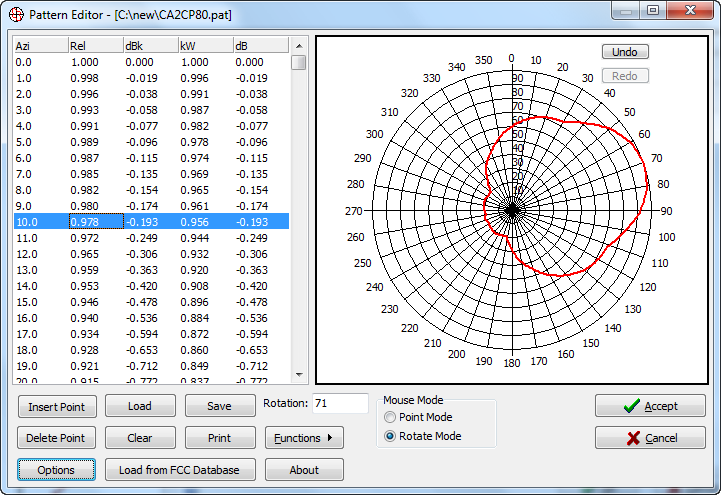
Pattern Workshop’s powerful pattern editor is included in the new Plus Pack bundle. Pattern Workshop’s editor integrates seamlessly with Probe 5, so when the program’s pattern editor is accessed, you use the much more powerful editor that is offered in Pattern Workshop. Patterns can be edited directly by drag and drop from the antenna field value’s chart while having full view of the impact of changing one of the variables on the all the others. A truly special feature of the Pattern Workshop editor is its significantly improved printing capabilities. Probe patterns can be individually printed on a great looking azimuth chart. Field values can be printed to numerous user selected tables. As per FCC requirements, any portions of patterns having values under ten percent of the maximum will be broken out and displayed on the same azimuth chart at 1/10th reduced scale. See: Pattern Workshop
4. Zip Code Module
This module gives Probe the ability to plot zip code boundaries and to calculate the population within them when coverage studies are performed. A report containing the field strengths at each zip code location can be generated. The option includes the latest zip code centroid data set as released from the U.S. Postal Service.
5. Airport Module
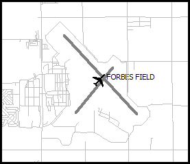
This module will name and plot airports on Probe maps. The module also supplies a graphical airport layout runway system that can be plotted on maps. This is particularly useful when hunting for tower sites within certain distances from airport runways.
6. ITU-R P.1546-1 Propagation Model
This propagation model is based on the International Telecommunications Union (ITU) standards. The model is considered a significant propagation breakthrough that provides our Probe 5 with another powerful prediction algorithm that can be used world-wide as well as in North America to predict signal coverage and interference in accordance with the ITU standards. The ITU model can be used either as a contour method or as a grid/area based system that uses pools of colors to differentiate between signal levels.
7. 1:250,000 (200 m) LULC Data
This 200 meter land cover database provides a significant upgrade to the original LULC database (1:1,000,000) that was package with Probe. Use of this database will enhance any R.F. Signal predictive method.
8. Canadian FM and TV station databases
These database files, in the standard V-Soft Communications format, are updated daily and include the distance-to-contour station files protected by Industry Canada.
9. Database Updates
Free download of database updates for zip code boundaries, zip code centroid locations, and airport locations.
10. 2010 Tiger Geographic Data
This data set includes:
2010 County Lines, 2010 State Boundaries, 2010 City/Place Boundaries, 2010 Urban Area Boundaries, 2010 Consolidated City Boundaries, 2010 MSA (Metropolitan and Metropolitan Statistical Area) Boundaries, www.v-soft.com/web/2010_Tiger_data.htm.
Plus Pack Bundled FMCommander Options:
The Plus Pack also enables the following FMCommander options:
Internet Mapping Capabilities – Click a Button to:
- Plot your site on a Google or Bing map at the precise coordinates
- (Important!) Plot a coverage contour or a “usable area” study on a Google Earth Map
- Plot your site on a U.S. Topographical map.
- Show your site on a MS TerraServer, or a Google Street Map.
- Show the U.S.G.S. Map Store site where you can purchase full size topographic maps
2010 Tiger Geographic Data, these FMCommander files include updated urban areas, county lines, county names and county boundaries
Airport Overlay Files: Plots airports on FMCommander maps
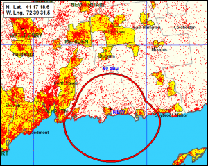
Population Scatter Gram Overlay: Plots Census database scatter grams (shown above)
Price: $550 per quarter. Everything listed above is included in your quarterly subscription.
Call to order your Plus Pack subscription today, 319 266-8402, or email “info at v-soft.com”.


