What’s new in AM-Pro 2
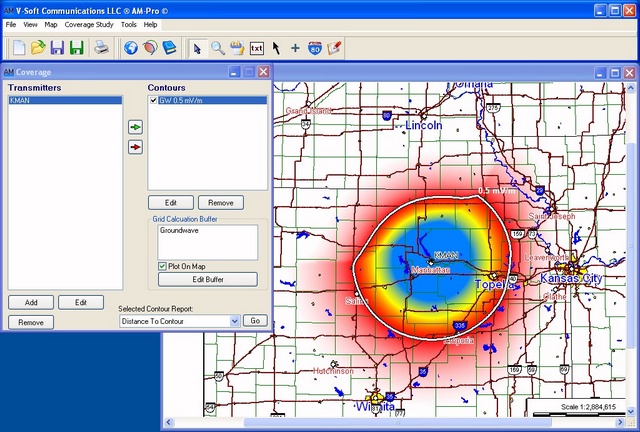
Here’s a screen shot of an AM coverage map using grid-based gradient shading signal value colors:

AM-Pro 2 is a major upgrade to V-Soft’s already powerful AM allocation and coverage mapping platform. In addition to numerous powerful upgrades, this new version supports “grid style” calculation of ground wave and sky wave field strengths and interference.
 Daytime allocation studies are enhanced by the ability to remove overlap area over water and accommodation for the existing facility. Night allocation studies now support full ‘clipping’ studies.
Among the new features of AM-Pro 2 are the following:
- Enhanced equivalent distance methodology for quick limit and point location field strength calculation.
- New database searching system where a table of ‘matches’ is reported (like in Probe)
- Ability to edit the AM database (and/or create custom databases)
- Ability to add a special radial or radials at a non-integer number of degrees.
- User definable border color and width specification for contour display.
- Ability to ‘fill’ contours with a user specified color.
- Revamped and advanced pattern editor for quicker response and flexibility. Also includes the ability to resize the advanced editor window and zoom in on a specific part of the graph.
- Interference areas over water can be eliminated from calculated interference areas and maps.
- Enhanced contour plotting for daytime allocation to show only the reference station contours that are relevant to the currently selected station(s).
- Ability to plot and ‘highlight’ the existing facility station contours in daytime allocation studies.
- Handles class C stations where power has been reduced from 1 kW (with increased efficiency).
- Daytime radiation limit calculation speed has been significantly increased.
- Ability to determine contour overlap areas and include polygons in those areas.
- Ability to move city names to desired location, set populations, or remove.
- For day studies added ability to change the channel of the reference station without rerunning the study.
- Cancel Button for initial night and day allocation studies (so the user can go back to the ‘wizard’ and change a setting if a mistake was made)
- Remove day time limits that are at ‘water’ points for interactive pattern editor (option).
- Support for full “clipping” studies for nighttime studies.
- Addition of a user defined “point protection” for night allocation.
- Ability to specify a user defined boundary for clipping purposes on nighttime studies
If the “existing facility” for a class D station is picked up it will be now included as a contributor in an RSS study. - Provide the ability to calculate “grid style” ground wave and skywave coverages.
- Added a ‘default’ setting for single station RSS studies (for station selection).
- Added quick NIF contour level calculation to coverage study.
- Ability to calculate/plot “grid style” interference. (similar to Probe)
- Automatic calculation of critical hour radiation limits.
- Exports coverage studies to KML (Google Earth) files.
- Has the ability to run daytime and nighttime studies using the FCC’s proposed AM Revitalization rules.
