
FMCommander
Now with the 2020 US Census and Expanded LPFM Features
Click here for video Introductions and demonstrations
(Important Features List)
Minimum Separations Tabular Study
FMCommander unites powerful contour-to-contour and FCC separation-study engines with instantaneous, interactive mapping. The result is a professional-grade toolkit that helps engineers uncover upgrade opportunities, evaluate short-spaced moves, optimize translator and booster placements, and model LPFM facilities with precision.
Built on the same advanced polygon-mapping database used in our Probe and AM-Pro systems, FMCommander produces atlas-quality FCC coverage and interference maps. Its drag-and-drop editing tools let you reposition labels, assign colors, draw arrows, apply intelligent text boxes, and perform multiple undos with ease. The integrated antenna-pattern editor automatically constructs directional patterns and allows point-by-point drag-and-drop adjustments directly on the azimuth chart.
FMCommander includes a fast, intuitive terrain profiler: just click any two map points to generate an immediate terrain-elevation graph.
Using the minimum-separations screen, you can model the 70 dBu principal city contour—or any other contour level—with a single mouse click. (See our YouTube overview of FMCommander’s minimum-separations studies.)
The program automatically calculates population counts within any service contour using the included 2020 U.S. block-level census data.
All core map layers—county lines, political boundaries, cities, water features, AM towers, and FM zone boundaries—are included. Optional overlays add population scattergrams, airport and railroad mapping, and FCC tower-registration plotting.
Contour-to-Contour Studies
The following example is a contour-to-contour ‘interference’ table showing that there is 3.2 km of incoming contour overlap to KUNY from KZSE, Rochester. (Years ago, this overlap was waived by the FCC, but its not likely today.)

The contour studies show the amount of prohibited contour overlap or clear space in two, easy to read, columns labeled “In” for incoming overlap and “Out” for the overlap that the reference station may cause to other stations. The amount of Contour Overlap is represented by the shortest distance between the appropriate interference contours and protected contours. (A map of these contours is shown below.) Lack of contour overlap, received or caused, can be confirmed when the map shows no overlaps. For the text display, negative distances, colored in red, indicate the intrusion of an interference contour over a protected contour of another station. For such screen displays, FMCommander automatically checks 180 degrees of arc between the interference and protected contours of the station under study. If overlap is found ‘along any azimuth’, the ‘Main Screen’ call letters of the affected station will turn red and the greatest amount of contour overlap will be shown, as above, in the table listing.

The contour-to-contour screen, above, maps the actual overlap that KUNY has with with KZSE. Click here to see a complete allocation map study for KUNY, created with one click of the “Allocation” icon.
The program quickly calculates the maximum power allowable in any direction. The effect of terrain attenuation and directional antenna is automatically applied. FMCommander interfaces transparently with V-Soft Communication’s application of the 30-arc-second, or 30-meter high ‘rez’ digital terrain databases. For maximum agreement, these are the actual databases in daily use by engineers at the FCC. Other terrain elevation databases that can be used by the program include the V-Soft U.S.G.S. 3 arc-second, the National Elevation Datum (NED) 3 second or 30-meter terrain elevation databases, the V-Soft cloud-corrected, shuttle, 3-arc-second Radar Topography Mission database and the GLOBE 30-arc-second terrain database.
FMCommander provides fully customizable screens, map backgrounds, font selections and colors. (Click here to see the Main Screen using a dark background with multi-colored text fonts.)
Separation Studies
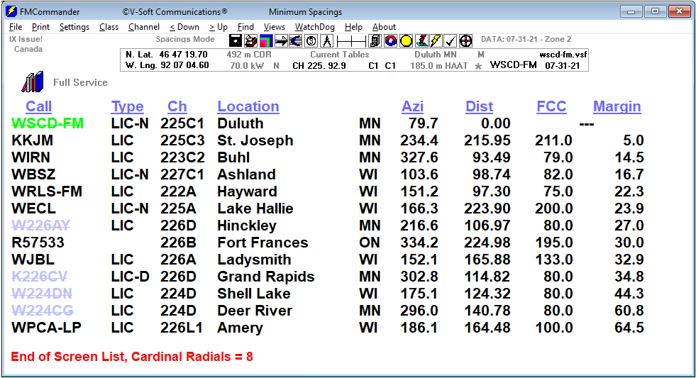
In the example below, FMCommander shows a standard FM minimum spacing map using the FCC rules in section 73.207. In the cases when needed short spacing Section 73.215 is used.

Its map screen are interactive. If you click the map at a given location, the program will recalculate the study using the coordinates of your point as the reference station’s location. The minimum spacing circles are plotted at each relevant transmitter location and they define areas where another transmitter ‘cannot’ be located on a given channel. The map above demonstrates a large area-to-locate in the southern half of Cape Cod making a drop-in channel possible. Separation-circles areas can be filled with a color that makes the drop-in location easily visible.

The following separations are included:
- Current FCC tables, including LPFM
- Former tables, as amended
- 3 kW Class A reference tables
- Puerto Rico & U.S. Virgin Islands tables
- LPFM-specific minimum-distance tables
- Plus the proposed, but never adopted, A10 tables
The user will note that the separation tables used with particular job files will be saved with the file, and are retrievable on future job file loads.
FMCommander displays the station’s operating parameters when you click on a station’s call letters from the main screen listing. You can resize this screen or any of the map screens or table screens by dragging a corner.
The coverage map below is a “graphics only” coverage capture from the program’s “Find Information” screen.

Pattern Editor:
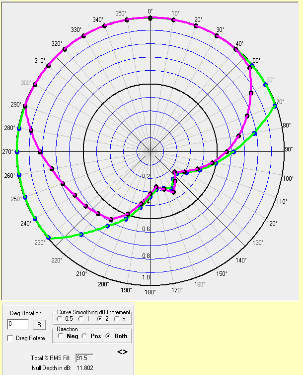
The azimuth chart below is from the new pattern editor showing both a proposed pattern limit (green) and the actual manufacturer’s pattern (Purple). Once displayed, the user can interactively adjust the pattern points to fit inside the limit. The FCC requirement is to have at least an 80% match. The label in the bottom left-hand corner shows that the match is 91.5% and the null depth is 11.802 dB. (The FCC requires an 85% match with the pattern and a null depth less than 15 dB as proposed within the application for construction permit.)
Rule Compliance:
FMCommander builds in numerous compliance checks to prevent the user from making mistakes, such as producing a station that exceeds the maximum distance service contour for its class. An example of one of the helpful pop-ups is shown below:

Help Screen
An extensive help-screen pops up to remind the user of the program’s operating instructions. It also conveniently includes many of the extra tables found the Rules.
Specialized Translator Routines
If you are working with a translator, either fill-in or non-fill-in, FMCommander has some special routines that will tell you whether your power on a given radial azimuth is over the maximum according to the rules. For the non-fill-in translator studies, a pop-up reports the azimuth of the bad radials and what the maximum power should be. The program always knows which zone the translator is in.
Channel-Six protection
In addition to contour-to-contour interference checks for non-commercial educational FM studies, FMCommander features an array of convenient routines to determine if interference is caused to full-service channel-six TV, as spelled out in Sec 73.525 of the Commission’s rules. The program will map the channel-six interference area and the protected grade B contour of channel-six TV station. As a part of this process, FMCommander searches the television database for channel-six stations within the cut-off distance. The protected grade B (and grade A) contour for all such TV-6 stations is automatically calculated as is the allowable signal of the FM station at such contours. The program will determine maximum power when the FM station is co-located with a channel-six television station. For a video on a few of the ‘Find Information Mapping Screen’s’ features, click here.
Special Features
FMCommander’s separations tables uses the FCC’s revised I.F. separations, which include the channel 253 to channel-six TV relationship. The program automatically uses the latest Canadian treaty separations and relevant Canadian protected contour values. Minimum separations from the 1994 Mexican treaty, as revised in 1997, using international class classifications, are applied when there is a relationship with Mexico.
FMCommander features an “automatic tracking” routine for searching for open channels. Simply place the program it in the “Seek” mode and let it do the searching for you.
The “C0 downgrade” feature will automatically downgrade all class C stations with an HAAT below 450 meters to the C0 class. This allows the user to find drop-ins and upgrades that require C0 downgrades to fit. All stations capable of being downgraded to C0 are suitably labeled with an underline of the call signs or the light blue color separation circle for maps.
Protected Zones

At the click of your mouse, FMCommander will perform a “Protected Zones” report.
Compatability
The program uses the same station assignment data that is in major use at the FCC. All signal contours are derived from the Commission’s F(50-10) table using the actual FCC TVFMINT FORTRAN algorithm as published in FCC report No. RS 76-01 by Gary C. Kalagian.
Printouts
FMCommander’s printouts show the radiated power, antenna HAAT & COR AMSL, distance to, azimuth to, reverse bearing from and geographic coordinates of each pertinent station. They include the exact distance of the database station’s protected and interference signal contours. The print-outs include information on whether the station operates as an old rule directional or a new rule Sec.73.215 directional and they list information on antenna polarization, beam tilt, licensee ownership, file and facility numbers and cut-off dates.
Click below for a PDF file example of FMCommander’s various printouts.
Contour-to-contour printout (PDF)
Standard spacings printout (with comments, PDF)
Standard spacings printout (Long form, PDF)
Spacings Printout with graphic (PDF)
Standard spacings preclusion printout. (PDF)
The integrated database screen (Station Filer) allows the user to easily access, change or correct the FCC’s database information if needed. Multiple key searches of the full FCC database can be performed allowing the user to direct the collected screen list, to a printer or text file. The “filter” can be used to select those stations that match the query criteria within a user’s set distance. If a station has a directional antenna pattern, the “Pattern” button will be visible. Clicking this button will open an azimuth pattern display plotting the pattern along 36 or 360 points with any ‘extra’ pattern points that may be included. The extra pattern points will also be shown in the display’s tabular field value listing.
Special Mapping Module
FMCommander has an optional Internet Mapping Module, that allows synchronization and interactivity with Google Earth and a other internet map sites.
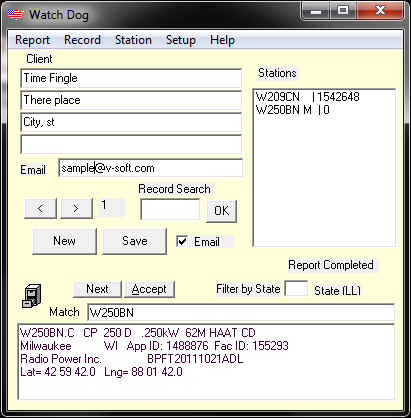
FCC Database Monitoring
The new WatchDog™ option has been completely updated. This module allows the user to prepare a list of addressees and stations’ call signs to be used in automated studies. Full channel-studies containing Sec. 73.207 separations reports and Sec. 73.509 contour-to-contour reports, for each station on the user’s list, can be sent through automatic email attachments. The screen shots, seen below, show the module’s main and setup screens. The program is opened by a menu item on the FMCommander Mainscreen.

FMCommander was created by senior engineering consultant Doug Vernier. The newest release adds many new and powerful features. V-Soft Communication’s programs are widely used by technical consultants and broadcast engineers throughout the U.S. The program is now packaged with the official 2020 group block US Census population data and the FCC’s most recent FM database, that includes channel-five, six and LPTV television station data. Users in the support program can receive regular access to program and database updates. Fresh database downloads are available every day.
Our telephone and email technical support program provides support for FMCommander and all the other V-Soft Communications programs.
For more on FMCommander please give us a call at 319-266-8402 or contact us online.