
 Probe 5™
- Probe 5 Brochure (.pdf)
- U.S. Map Gallery
- World Map Gallery
- New Probe 5 Features
- Probe Version Tier List (Basic/Standard/Professional)
- OET 69 Module (Sample DTV Study)
- Longley-Rice Propagation Model
- V-Soft Plus Pack (Optional Module Subscription)
- Methodology

Spectacular Signal Mapping!
Propagation Software for Communications, DTV, FM, LPTV
Probe gives you the ability to be an expert at predicting radio propagation in the 20 to 20,000 MHz. frequency range. Now the newly released Probe 5 offers more powerful features, flexibility and speed, including the ability to take advantage of multiple program threads and dual core or quad core processors.
With dozens of new useful features Probe 5 has become a fully 64-bit application. This means it can use the entire RAM on your computer and is not limited to just 2GB.
Recently Added – ATSC 3.0 Calculation Tool
 This new Probe 5 feature will calculate the required C/N and noise limited field strength for various ModCods (modulation & code rate) and associated values selected for an ATSC 3.0 Physical Layer Pipe (PLP). The C/N calculation is performed as outlined in Annex B of of the ATSC A/327 recommended practice. More Info…
Probe is designed to be as flexible as possible to accommodate the various requirements of propagation analysis for multiple communication services. From 800 MHz two-way communication performance to the the FCC’s DTV interference rules, Probe is the choice as the universal propagation prediction tool.
Here is a short introduction video to Probe 4 that also applies to the new Probe 5:
Critical to Probe’s success is its professionally integrated, world wide, geographic mapping engine which combines the best polygon mapping graphics available with precision coordinate information and map projections. Probe produces absolutely stunning maps with appearances that rival even the best of the traditional atlas map makers. All background colors, highway colors and road markers, city names, river line-thickness, lake and ocean colors and label font names and sizes are fully user-selectable. You can configure every aspect of Probe’s maps right down to the street level to make them look perfect to the intended reader. The program contains a complete set of editing and drawing tools for adding text, pointer arrows, circles, squares, lines and other information to the maps.
Probe’s what-you-see-is-what-you-get interface provides you with a screen view of the exact printed output. The program builds in a mouse-zoom feature which enables the you to enlarge any rectangle you select on the map to full screen so that the selected area can be examined in detail or printed. Maps, scaled selected to your choice, can be sent to color or black and white printers or can be internally converted to graphic files.
Probe 5 offers a polygon drawing tool that allows the user to enhance maps by highlighting certain areas. When the tool is used in the polygon mode, users can form a shape on the screen with the mouse and Probe will calculate the population and area within the shape. This tool is particularly useful for calculating the population and areas of odd contour overlaps or interference area shapes.
Single or multiple station communications or broadcast coverage studies, incoming or outgoing interference studies, highest signal two-way coverage are all available for user selection. For broadcast related interference studies, Probe automatically identifies the stations to which interference is caused, as well as those stations which cause interference to the user’s reference station facilities.
Probe uses any of the numerous V-Soft Communication’s terrain elevation databases. (Databases of 3 arc-seconds are available from V-Soft Communications for Canada, USA, Mexico, Caribbean, Central America and South America, Europe, Asia, Australia and New Zealand.) Thirty arc-seconds resolution terrain databases are also available for anywhere in the World. In addition to the Longley-Rice (TECH-NOTE 101) methods, Probe also uses the ITU-R Model, the Federal Communication’s Commission “FCC” propagation model, the Okumura/Hata/Davidson and Cost-231/Hata propagation models, the FCC’s proposed PTP V:1 and V:2 (point-to-point) methods, and now with the new addition called NSMA OHLOSS, ideal for calculating high frequency path loss . (The PTP method, authored by the FCC’s Harry Wong, is primarily based on Fresnel clearance.) Terrain Integrated Rough Earth Model (TIREM) methodology is available as an option.
Available as an option, ITU propagation model (P. 1546) based on the International Telecommunications Union (ITU) rules and regulations is available. This is a significant propagation breakthrough that allows our Probe 5 to be used in tandem with our global SRTM 03 arc-second digital terrain elevation database to predict signal coverage and interference in accordance with the ITU standards anywhere in the world. The ITU model can be used either as a contour method or grid/area system that uses colors to differentiate between signal levels, similar to the current Longley/Rice propagation model.
For DTV analysis, Probe’s optional DTV OET-69 module calculates the population and area of broadcast TV interference using the precise method prescribed by the FCC.
Tabular signal level output is available for all methods including a complete array of tabular outputs in the CSV (Comma Separated Value) format… thus facilitating importing to spread-sheets. Probe also includes a MapInfo MIF input and output format so signal information can be exported to various GIS systems and geo-map data can be imported into Probe.
For U.S. and Canada users, A detailed census block-level database is included which allows the tabulation of, county by county, ethnic demographics and household and population totals. In the coverage mode, Probe features a hot cursor that, when placed over a detail on the map, will display the coordinates, elevation, land-cover, signal levels or interference U/D at the cursor location.
Probe will also do ILLR calculations using the Longley-Rice “individual mode”, 03 sec terrain database with 0.1 kilometer sampling as is required under the FCC’s latest rules relating to the Satellite Home Viewers Act. The user can input a street address and Probe will identify the location and determine the signal strength at the point.
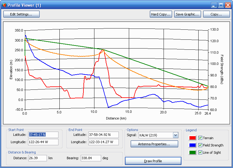
The profile tool (see image below) will graph the elevation and signal profile between a transmitter point and a desired receive point at a user selected earth curvature. Probe also has a line-of-sight mapping mode that will identify all ground locations where a line-of-sight is available to the transmitting antenna.
 Probe 5 has an interactive directional antenna editor and comes packaged with the latest TV, DTV and FM FCC engineering and directional antenna databases, the U.S. 2020 Census population database (more recent U.S. Census Estimate data update is available as an option), a land-cover database and a high resolution polygon mapping database. (Global databases are available.) Click one of the extended feature links at the top of this page for more information or visit our on-line Probe U.S. or international galleries.